Remote Sensing at the Waterfront
Recently, Professor Colin Grier and a small team of students from Washington State University Vancouver (WSUV) began a remote sensing survey of the project area for the 2021 Public Archaeology Field School. While the field school will include students from WSUV and Portland State University, this portion of the field work is being spearheaded by by Grier's WSUV team. They began by setting up a baseline using an existing survey datum and setting the Field School datum near where we will being conducting archaeological investigations this summer. The project area is south of the BNSF railroad tracks and visible from the Confluence Project land bridge.
 |
| Professor Grier and crew set up project datum. The BNSF railroad berm with the Water Overlook of the Confluence Project Land Bridge peeking above are visible in the background. (NPS photo) |
 |
| Grier explains the grid & GPR to the students. (NPS photo) |
WHAT IS A SITE DATUM?
A site datum is a point that is keyed to a coordinate geographic referent -- in other words it is able to be mapped using a standard coordinate system and a projections. Many archaeologists use the universal transmercator system (UTM) to map their sites as that is often required by state historic preservation offices. For our field school we will use Washington State Plane South with the 1983 North American Datum (NAD83) to map in all of our units as that is how our Geographic Information System (GIS) is set up.
On the ground, however, we will set up our grid using the metric system as we will be recording our units using the "language of science." The datum point that Dr. Grier established will be designated 1000 meters east and 1000 meters north of an imaginary datum. An imaginary datum is a point that is not mapped but is an arbitrary designation that allows us to work entirely in eastings and northings or X,Y dimensions (no negative numbers or westings and southings). Students will be trained in how to identify points on the grid and how that relates to how we carefully record everything in three dimensions (northing, easting, and elevation). Careful recording of our data is an important part of archaeological field methods.
WHAT IS GROUND PENETRATING RADAR?
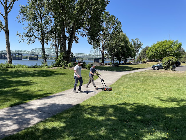
After setting up the grid, the team ran the radar to explore the sediments below the ground surface. The GPR kind of looks like a lawn mower but instead of cutting grass it sends radar waves into the ground and records the reflections when they bounce off of things. This project is tiering off of Dr. Grier's research with the National Science Foundation, which is using geophysical prospection methods, including GPR, to visualize archaeological sites and their strata and features without excavation. This will provide a radar "anomaly" map to help position archaeological excavations this summer. It is hoped that the work this summer will help interpret the variations in radar wave to "read" what specific buried archaeological resources look like, like pits, hearths, and houses. For more information on GPR, check out this NPS page: https://www.nps.gov/articles/000/preservation-in-practice-gpr.htm
 |
| Dr. Colin Grier running the GPR on the grid at the Fort Vancouver waterfront in preparation for the 2021 Public Archaeology Field School. (NPS photo). |

I cannot wait!! After working with Dr. Grier and Dr. Wilson in preparation for the field school I must say I haven't been so excited to attend something in many years. I can't wait to meet and work with everyone.
ReplyDeleteJoshua